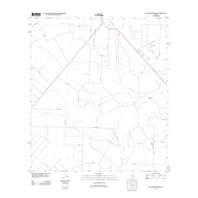
2013 Map of Bullshead Creek
USGS Topo · Published 2013About this map
Bullshead Cr and its tributaries carve a network through this agricultural landscape in San Patricio County, illustrating the rural drainage patterns essential to Texas ranching and farming operations. The area is defined by its extensive local road system, featuring family-named routes such as Fovilish Rd and an array of numbered county roads like Co Rd-510 and Co Rd-529 that partition the large parcels of land. The terrain includes distinctive natural features like Mcfall Draw and the gentle basin of Dale Hollow, which collect runoff for the larger Papalote Cr. This survey documents a quiet interior section of the Coastal Bend, where the presence of numerous Private Roads suggests the ongoing importance of private landholdings and isolated homesteads far from the region's larger population centers.
Find a feature on this map
46 named features on this map. Tap any name to fly to it.
Don’t see what you’re looking for? This feature index may not catch every label — zoom into the map to look around manually.
Map Details
Editions of this 2013 Bullshead Creek Map
This is the sole edition of this map. No revisions or reprints were ever made.
Other maps of this area

1927 · Mathis
USGS Topo · 1:62,500

1953 · Beeville
USGS Topo · 1:250,000

1954 · Skidmore
USGS Topo · 1:62,500

1954 · Fleming
USGS Topo · 1:62,500

1954 · Mathis
USGS Topo · 1:62,500

1954 · Sinton
USGS Topo · 1:62,500

1956 · Beeville
USGS Topo · 1:250,000

1960 · Beeville
USGS Topo · 1:250,000

1979 · Burkes Ridge
USGS Topo · 1:24,000
1979 · Sinton West
USGS Topo · 1:24,000