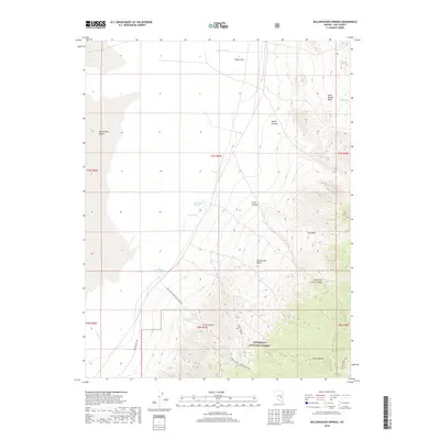
2018 Map of Bullwhacker Springs
USGS Topo · Published 2018About this map
Humboldt National Forest dominates the southern reaches of this landscape, where the high peaks of the Grant Range give way to a network of steep drainages. The area is defined by its critical water sources, including the namesake Bullwhacker Springs and others like Irwin Canyon Springs and Willow Springs, which serve as vital points in an otherwise arid basin-and-range environment. These springs historically supported the small-scale ranching and transit that defined central Nevada's high desert.
Find a feature on this map
29 named features on this map. Tap any name to fly to it.
Don’t see what you’re looking for? This feature index may not catch every label — zoom into the map to look around manually.
Map Details
Editions of this 2018 Bullwhacker Springs Map
This is the sole edition of this map. No revisions or reprints were ever made.
Other maps of this area

1956 · Lund
USGS Topo · 1:250,000

1960 · Lund
USGS Topo · 1:250,000

1964 · Blue Eagle Springs
USGS Topo · 1:62,500

1964 · Currant
USGS Topo · 1:62,500

1964 · Troy Canyon
USGS Topo · 1:62,500

1964 · Forest Home
USGS Topo · 1:62,500

1980 · Duckwater
USGS Topo · 1:100,000

1988 · Quinn Canyon Range
USGS Topo · 1:100,000
1990 · Troy Canyon
USGS Topo · 1:24,000
1990 · Blue Eagle Mountain
USGS Topo · 1:24,000