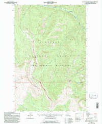
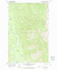
1994 Map of Bungalow Mountain
USGS Topo · Published 1997About this map
The Bob Marshall Wilderness dominates this mid-1990s terrain, revealing a high-alpine landscape defined by the drainage of the Spotted Bear River. High peaks such as Bungalow Mountain and Ibex Mountain watch over a network of glacial-fed streams, including Silvertip Creek and Slim Creek. The dramatic topography is anchored by the Wall Creek Cliffs and the presence of active glaciers and a glacier remnant tucked into north-facing basins. To the south, the White River winds through the Flathead National Forest, joined by smaller tributaries like Juliet Creek and Rooney Creek. This map captures a pristine section of the Northern Rockies before modern climate shifts further impacted the namesake ice features found near Wall Creek.
Find a feature on this map
21 named features on this map. Tap any name to fly to it.
Don’t see what you’re looking for? This feature index may not catch every label — zoom into the map to look around manually.
Map Details
Editions of this 1994 Bungalow Mountain Map
This is the sole edition of this map. No revisions or reprints were ever made.
Other maps of this area

1936 · Silvertip
USGS Topo · 1:96,000

1942 · Silvertip
USGS Topo · 1:125,000

1955 · Choteau
USGS Topo · 1:250,000

1957 · Choteau
USGS Topo · 1:250,000

1958 · Choteau
USGS Topo · 1:250,000

1962 · Choteau
USGS Topo · 1:250,000
1970 · Cathedral Peak
USGS Topo · 1:24,000
1970 · Whitcomb Peak
USGS Topo · 1:24,000
1970 · Trilobite Peak
USGS Topo · 1:24,000
1970 · Pagoda Mountain
USGS Topo · 1:24,000