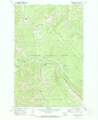
1970 Map of Whitcomb Peak
USGS Topo · Published 1973About this map
The Spotted Bear River carves a deep valley through this Montana backcountry, serving as a primary corridor for travel before the establishment of modern infrastructure. This 1970 field-checked survey reveals a landscape defined by its primitive access and administrative presence within the Flathead National Forest. The Wilderness Boundary bisects the map, marking the northern edge of the Bob Marshall Wilderness and isolating peaks like Whitcomb Peak and Sergeant Mountain from developed areas.
Find a feature on this map
36 named features on this map. Tap any name to fly to it.
Don’t see what you’re looking for? This feature index may not catch every label — zoom into the map to look around manually.
Map Details
Editions of this 1970 Whitcomb Peak Map
2 editions found
Other maps of this area

1913 · Marias Pass
USGS Topo · 1:125,000

1936 · Silvertip
USGS Topo · 1:96,000

1942 · Silvertip
USGS Topo · 1:125,000

1955 · Choteau
USGS Topo · 1:250,000

1957 · Choteau
USGS Topo · 1:250,000

1958 · Choteau
USGS Topo · 1:250,000

1958 · Gable Peaks
USGS Topo · 1:24,000

1958 · Capitol Mountain
USGS Topo · 1:24,000

1958 · Horseshoe Peak
USGS Topo · 1:24,000

1960 · Cut Bank
USGS Topo · 1:250,000