
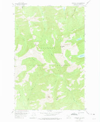
1958 Map of Horseshoe Peak
USGS Topo · Published 1960About this map
Flathead National Forest defines this high-elevation landscape, dominated by a series of prominent summits and glacial lakes. Centered on Horseshoe Peak and Hematite Peak, the terrain is carved by a network of drainages including Head Creek, Dryad Creek, and Trinity Creek. The map documents a primitive transportation network consisting of several pack trails that navigate the ridges between peaks like Condor Peak and Spy Mountain. These trails connect remote water bodies such as Flotilla Lake and Bradley Lake, providing a clear record of the backcountry access routes used in the late 1950s. The absence of roads emphasizes the wilderness character of the region during this mid-century survey period.
Find a feature on this map
22 named features on this map. Tap any name to fly to it.
Don’t see what you’re looking for? This feature index may not catch every label — zoom into the map to look around manually.
Map Details
Editions of this 1958 Horseshoe Peak Map
2 editions found
Other maps of this area

1913 · Marias Pass
USGS Topo · 1:125,000

1914 · Nyack
USGS Topo · 1:125,000

1936 · Silvertip
USGS Topo · 1:96,000

1942 · Silvertip
USGS Topo · 1:125,000

1955 · Choteau
USGS Topo · 1:250,000

1957 · Choteau
USGS Topo · 1:250,000

1958 · Choteau
USGS Topo · 1:250,000

1958 · Red Plume Mountain
USGS Topo · 1:24,000

1958 · Capitol Mountain
USGS Topo · 1:24,000

1958 · Circus Peak
USGS Topo · 1:24,000