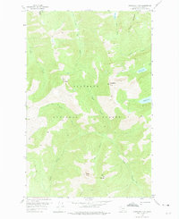
1958 Map of Horseshoe Peak
USGS Topo · Published 1975About this map
Flathead National Forest encompasses the entirety of this 1958 survey, capturing a high-altitude wilderness defined by the Horseshoe Peak and Trinity Mountain massifs. The landscape is characterized by a network of drainage basins, where the headwaters of Castle Creek, Dryad Creek, and Spy Creek carve deep valleys through the mountain ranges. Higher elevations are marked by isolated alpine features like Flotilla Lake and Bradley Lake, which sit below the ridgelines of Hematite Peak and Twin Mountain. This area is navigated almost exclusively by a system of Pack Trails, emphasizing its isolation and lack of vehicular infrastructure during the late 1950s. The presence of Condor Peak and Spy Mountain further illustrates the complex topographic profile of this interior Montana wilderness, used primarily for resource management and backcountry transit.
Find a feature on this map
22 named features on this map. Tap any name to fly to it.
Don’t see what you’re looking for? This feature index may not catch every label — zoom into the map to look around manually.
Map Details
Editions of this 1958 Horseshoe Peak Map
2 editions found

Other maps of this area

1913 · Marias Pass
USGS Topo · 1:125,000

1914 · Nyack
USGS Topo · 1:125,000

1936 · Silvertip
USGS Topo · 1:96,000

1942 · Silvertip
USGS Topo · 1:125,000

1955 · Choteau
USGS Topo · 1:250,000

1957 · Choteau
USGS Topo · 1:250,000

1958 · Choteau
USGS Topo · 1:250,000

1958 · Red Plume Mountain
USGS Topo · 1:24,000

1958 · Capitol Mountain
USGS Topo · 1:24,000

1958 · Circus Peak
USGS Topo · 1:24,000