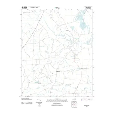
2010 Map of Bunnlevel
USGS Topo · Published 2010About this map
Harnett County terrain is defined by the convergence of several major water systems, including the Upper Little River and the lower Little River, which carve through the rural landscape near the community of Bunnlevel. The map reveals a high concentration of swampy lowlands such as Big Swamp, Williams Swamp, and Gum Swamp, which influenced the placement of early settlements and roads. The area around Walkertown and Fonville displays a pattern of small-scale water management, evidenced by the Byrd Mill Pond and Woods Lake Dam.
Find a feature on this map
70 named features on this map. Tap any name to fly to it.
Don’t see what you’re looking for? This feature index may not catch every label — zoom into the map to look around manually.
Map Details
Editions of this 2010 Bunnlevel Map
This is the sole edition of this map. No revisions or reprints were ever made.
Other maps of this area

1948 · Fayetteville
USGS Topo · 1:62,500

1948 · Slocomb
USGS Topo · 1:24,000

1950 · Manchester
USGS Topo · 1:24,000

1950 · Slocomb
USGS Topo · 1:24,000

1953 · Raleigh
USGS Topo · 1:250,000

1954 · Raleigh
USGS Topo · 1:250,000

1956 · Anderson Creek
USGS Topo · 1:24,000

1956 · Bunnlevel
USGS Topo · 1:24,000
1957 · Manchester
USGS Topo · 1:24,000

1957 · Fayetteville
USGS Topo · 1:62,500