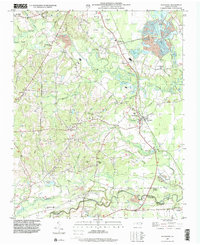
1997 Map of Bunnlevel
USGS Topo · Published 2000About this map
Upper Little River and the Lower Little River define the winding drainage patterns of this Harnett County landscape, which transitions into Cumberland County at its southern edge. The small settlements of Bunnlevel and Linden serve as local hubs, surrounded by a dense network of country churches that reflect the area's social history. Significant landmarks include Mt Pleasant Ch, Friendship Ch, and Tabernacle Ch, many of which are paired with established family burial grounds such as McArtan Cem and Friendship Cem.
Find a feature on this map
45 named features on this map. Tap any name to fly to it.
Don’t see what you’re looking for? This feature index may not catch every label — zoom into the map to look around manually.
Map Details
Editions of this 1997 Bunnlevel Map
This is the sole edition of this map. No revisions or reprints were ever made.
Other maps of this area

1948 · Fayetteville
USGS Topo · 1:62,500

1948 · Slocomb
USGS Topo · 1:24,000

1950 · Manchester
USGS Topo · 1:24,000

1950 · Slocomb
USGS Topo · 1:24,000

1953 · Raleigh
USGS Topo · 1:250,000

1954 · Raleigh
USGS Topo · 1:250,000

1956 · Anderson Creek
USGS Topo · 1:24,000

1956 · Bunnlevel
USGS Topo · 1:24,000
1957 · Manchester
USGS Topo · 1:24,000

1957 · Fayetteville
USGS Topo · 1:62,500