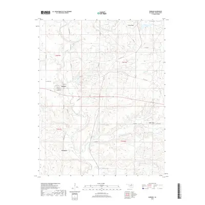
2018 Map of Burbank
USGS Topo · Published 2018About this map
Burbank and the surrounding Osage County landscape appear here in a transition between its industrial history and agricultural present. This region, characterized by the branching drainages of Salt Creek and Little Chief Cr, was once central to the Burbank Oil Field, reflected in place names like Carter Nine and the small settlement of Little Chief. The township grid system is well-defined by local routes such as Cameron Rd and Whizbang Rd, whose names hint at the area's early 20th-century boomtown legacy. North of the town center, Burbank Cem and Charlotte Lake provide specific landmarks for local history. The map also captures the path of Old State Hwy 18 and Old Hwy 60, tracing the evolution of transportation through the tallgrass prairie. To the south, the settlement of Remington sits near the headwaters of Solomon Cr, illustrating the dispersed nature of these historic rural communities.
Find a feature on this map
37 named features on this map. Tap any name to fly to it.
Don’t see what you’re looking for? This feature index may not catch every label — zoom into the map to look around manually.
Map Details
Editions of this 2018 Burbank Map
This is the sole edition of this map. No revisions or reprints were ever made.
Other maps of this area

1916 · Foraker
USGS Topo · 1:62,500

1932 · Fairfax
USGS Topo · 1:62,500

1935 · Kaw
USGS Topo · 1:62,500

1936 · Belford
USGS Topo · 1:62,500

1955 · Enid
USGS Topo · 1:250,000

1958 · Enid
USGS Topo · 1:250,000

1964 · Charley Creek NE
USGS Topo · 1:24,000

1964 · Kaw City
USGS Topo · 1:24,000
1964 · Shidler
USGS Topo · 1:24,000
1973 · Foraker South
USGS Topo · 1:24,000