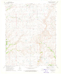
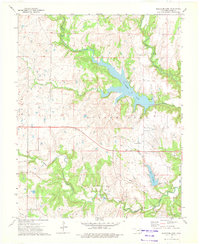
1973 Map of Foraker South
USGS Topo · Published 1975About this map
The Osage Indian Reservation covers the entirety of this 1970s landscape, illustrating a transition from the heavy rail era toward modern ranching and resource extraction. The community of Foraker sits near the northern boundary, while an Old Railroad Grade traces a path through the rolling prairie, marking the footprint of transportation routes that once served the region's cattle and oil industries. Evidence of the petroleum economy is found in scattered Oil Wells and Gas Wells that dot the terrain alongside major drainage systems like Middle Bird Creek and Potato Creek.
Find a feature on this map
24 named features on this map. Tap any name to fly to it.
Don’t see what you’re looking for? This feature index may not catch every label — zoom into the map to look around manually.
Map Details
Editions of this 1973 Foraker South Map
This is the sole edition of this map. No revisions or reprints were ever made.
Other maps of this area

1909 · Pawhuska
USGS Topo · 1:125,000

1910 · Pawhuska
USGS Topo · 1:125,000

1916 · Foraker
USGS Topo · 1:62,500

1932 · Fairfax
USGS Topo · 1:62,500

1955 · Enid
USGS Topo · 1:250,000

1958 · Enid
USGS Topo · 1:250,000
1964 · Shidler
USGS Topo · 1:24,000
1964 · Grainola
USGS Topo · 1:24,000
1973 · Pearsonia
USGS Topo · 1:24,000
1973 · Bluestem Lake
USGS Topo · 1:24,000