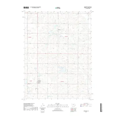
2017 Map of Burchard
USGS Topo · Published 2017About this map
The village of Burchard serves as the primary hub in this corner of Pawnee County, where the agricultural landscape is defined by an intricate network of water management projects. Numerous reservoirs, such as Rock Cr Reservoir 23-A and Plum Cr Reservoir 5-A, dot the drainages of Plum Cr and Rock Cr, illustrating modern soil and water conservation efforts in the Great Plains. These man-made bodies of water, including the significant Burchard Lake, contrast with the traditional grid of section-line roads like 612 Ave and 714 Rd. To the north, the small settlement of Mayberry sits near Mayberry Lake. For those tracing local heritage, the map identifies several burial sites, including Burchard Cem, Sacred Heart Cem, and the more isolated Rinne Cem near the northern boundary.
Find a feature on this map
58 named features on this map. Tap any name to fly to it.
Don’t see what you’re looking for? This feature index may not catch every label — zoom into the map to look around manually.
Map Details
Editions of this 2017 Burchard Map
This is the sole edition of this map. No revisions or reprints were ever made.
Other maps of this area

1955 · Lincoln
USGS Topo · 1:250,000

1957 · Lincoln
USGS Topo · 1:250,000

1958 · Lincoln
USGS Topo · 1:250,000

1965 · Pawnee City
USGS Topo · 1:24,000

1965 · Crab Orchard
USGS Topo · 1:24,000

1965 · Burchard
USGS Topo · 1:24,000

1965 · Tecumseh
USGS Topo · 1:24,000
1965 · Steinauer
USGS Topo · 1:24,000
1965 · Liberty SE
USGS Topo · 1:24,000

1965 · Lewiston
USGS Topo · 1:24,000