
1965 Map of Lewiston
USGS Topo · Published 1966About this map
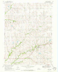
The small rural communities of Lewiston and Virginia anchor this mid-1960s landscape along the border of Gage and Pawnee counties. Settlement patterns follow the winding paths of Turkey Creek and its many tributaries, with small clusters of development centered around local institutions like the Pleasant Hill Ch and the Mt Pleasant Cem. The area is characterized by a dense network of country roads and drainage patterns, including Adamson Creek and Wildcat Creek, which define the agricultural topography of the Missouri River Basin. Rail transit plays a prominent role in the local geography, with the Chicago Rock Island and Pacific and the Burlington and Quincy lines cutting through the terrain, connecting these prairie outposts to larger regional hubs. This survey provides a clear look at the township structures of Sherman, Turkey Creek, Island Grove, and Plum Creek during a period of established mid-century farming life.
Find a feature on this map
22 named features on this map. Tap any name to fly to it.
Don’t see what you’re looking for? This feature index may not catch every label — zoom into the map to look around manually.
Map Details
Editions of this 1965 Lewiston Map
This is the sole edition of this map. No revisions or reprints were ever made.
Other maps of this area

1955 · Lincoln
USGS Topo · 1:250,000

1957 · Lincoln
USGS Topo · 1:250,000

1958 · Lincoln
USGS Topo · 1:250,000

1965 · Crab Orchard
USGS Topo · 1:24,000

1965 · Burchard
USGS Topo · 1:24,000
1965 · Liberty SE
USGS Topo · 1:24,000
1965 · Vesta
USGS Topo · 1:24,000
1965 · Liberty
USGS Topo · 1:24,000
1970 · Barneston
USGS Topo · 1:24,000
1970 · Filley
USGS Topo · 1:24,000