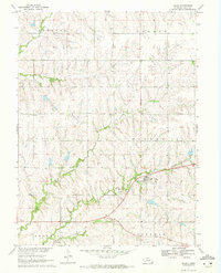
1970 Map of Filley
USGS Topo · Published 1972About this map
The village of Filley sits at the heart of this Gage County landscape, surrounded by the agricultural townships of Hanover, Hooker, Logan, and Sherman. The area is defined by its drainage into Bear Creek, Cedar Creek, and Mud Creek, with the latter flowing just south of the main settlement. An Old Railroad Grade cuts diagonally across the southern half of the sheet, tracing a path through the valley near Filley Cem. Genealogy researchers will find precise locations for local landmarks like Zion Cem in the northwest and the Radio Towers to the southeast. The map's detailed topography, compiled from 1968 aerial photography, captures the intricate network of section lines and field boundaries that organize this rural prairie terrain.
Find a feature on this map
17 named features on this map. Tap any name to fly to it.
Don’t see what you’re looking for? This feature index may not catch every label — zoom into the map to look around manually.
Map Details
Editions of this 1970 Filley Map
2 editions found
Other maps of this area

1955 · Lincoln
USGS Topo · 1:250,000

1957 · Lincoln
USGS Topo · 1:250,000

1957 · Beatrice East
USGS Topo · 1:24,000

1958 · Lincoln
USGS Topo · 1:250,000

1964 · Pickrell
USGS Topo · 1:24,000

1964 · Blue Springs
USGS Topo · 1:24,000

1965 · Adams
USGS Topo · 1:24,000

1965 · Crab Orchard
USGS Topo · 1:24,000

1965 · Sterling
USGS Topo · 1:24,000

1965 · Lewiston
USGS Topo · 1:24,000