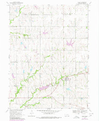
1970 Map of Filley
USGS Topo · Published 1980About this map
Filley and Rockford anchor this 1970 Nebraska survey, documenting a rural landscape structured by the local watercourses of Mud Creek and Cedar Creek. The map provides significant detail for family historians, noting Zion Ch and its associated Zion Cem in the northwestern corner, along with the Filley Cem just south of the village. A notable interpretive element is the Old Railroad Grade cutting across the southern half of the quadrangle, tracing the path of former transportation that once linked these agricultural communities. The terrain is further defined by its civic divisions, including the townships of Hanover, Hooker, and Logan. Modern infrastructure also appears, such as the Sewage Disposal Pond and several Radio Towers, marking the technological progression of Gage County in the late twentieth century.
Find a feature on this map
17 named features on this map. Tap any name to fly to it.
Don’t see what you’re looking for? This feature index may not catch every label — zoom into the map to look around manually.
Map Details
Editions of this 1970 Filley Map
2 editions found
Other maps of this area

1955 · Lincoln
USGS Topo · 1:250,000

1957 · Lincoln
USGS Topo · 1:250,000

1957 · Beatrice East
USGS Topo · 1:24,000

1958 · Lincoln
USGS Topo · 1:250,000

1964 · Pickrell
USGS Topo · 1:24,000

1964 · Blue Springs
USGS Topo · 1:24,000

1965 · Adams
USGS Topo · 1:24,000

1965 · Crab Orchard
USGS Topo · 1:24,000

1965 · Sterling
USGS Topo · 1:24,000

1965 · Lewiston
USGS Topo · 1:24,000