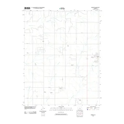
2010 Map of Burden
USGS Topo · Published 2010About this map
The town of Burden serves as the primary settlement on this landscape, with its residential grid structured around streets like Oak St and Willow St. This area of Cowley County is defined by a significant energy extraction economy, as evidenced by the distribution of the Shannon Oil Field, Burden Oil Field, and the Frog Hollow Oil Field. These industrial zones are interspersed with established rural landmarks, including the Salem Cemetery, Silver Creek Cemetery, and Tisdale Cemetery, providing clear spatial reference points for genealogists tracing family ties to the region. The natural drainage of the territory is dominated by the southward flow of Snake Creek, Silver Creek, and Plum Creek, while Timber Creek Lake creates a distinct water feature in the northwest. A rectilinear grid of rural roads, such as 152nd Rd and 181st Rd, connects these scattered oil operations and historic burial grounds across the Kansas prairie.
Find a feature on this map
39 named features on this map. Tap any name to fly to it.
Don’t see what you’re looking for? This feature index may not catch every label — zoom into the map to look around manually.
Map Details
Editions of this 2010 Burden Map
This is the sole edition of this map. No revisions or reprints were ever made.
Other maps of this area

1889 · Burden
USGS Topo · 1:125,000

1955 · Wichita
USGS Topo · 1:250,000

1958 · Wichita
USGS Topo · 1:250,000

1962 · Dexter
USGS Topo · 1:24,000

1962 · Cambridge
USGS Topo · 1:24,000

1964 · Cambridge NW
USGS Topo · 1:24,000

1964 · Burden
USGS Topo · 1:24,000
1964 · Atlanta
USGS Topo · 1:24,000

1965 · Eaton
USGS Topo · 1:24,000

1965 · Winfield
USGS Topo · 1:24,000