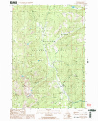
1989 Map of Burgdorf
USGS Topo · Published 1990About this map
The mountain settlement of Burgdorf serves as the focal point of this Idaho survey, which documents the remote high-country landscape during the late 1980s. Located within the Payette National Forest, the area is defined by a series of steep drainages including Lake Creek and Nethker Creek, which flow toward the Secesh River at the southern boundary. The presence of the Burgdorf Sch, Burgdorf RS Sta, and a Campground (Hot Springs) suggests a localized hub for forest management and thermal recreation. Evidence of mineral exploration and resource extraction is scattered across the terrain, notably at the Durden Prospect Mine and an Open Pit Mine near Crystal Mountain. Higher elevations are marked by landmarks like Bear Pete Mountain and Marshall Lake, while a network of Pack Trails provides access through the timbered slopes and clearings such as Frosty Meadow.
Find a feature on this map
34 named features on this map. Tap any name to fly to it.
Don’t see what you’re looking for? This feature index may not catch every label — zoom into the map to look around manually.
Map Details
Editions of this 1989 Burgdorf Map
2 editions found
Other maps of this area

1938 · Riggins
USGS Topo · 1:96,000

1945 · Riggins
USGS Topo · 1:125,000

1955 · Grangeville
USGS Topo · 1:250,000

1956 · Burgdorf
USGS Topo · 1:62,500

1956 · Elk City
USGS Topo · 1:250,000

1959 · Grangeville
USGS Topo · 1:250,000

1960 · Elk City
USGS Topo · 1:250,000

1963 · Black Tip
USGS Topo · 1:24,000

1963 · Hershey Point
USGS Topo · 1:24,000
1964 · Kelly Mountain
USGS Topo · 1:24,000