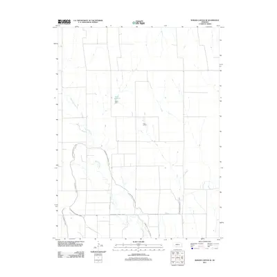
2011 Map of Burger Canyon SE
USGS Topo · Published 2011About this map
Blackwood Creek meanders through this agricultural landscape in Red Willow County, defining the local hydrology alongside a complex network of man-made irrigation infrastructure. The presence of the Culbertson Canal, Culbertson Extension Canal, and the Blackwood Lateral Canal highlights the significance of water management in this portion of Nebraska. These features, along with the Miller Reservoir and its associated Miller Dam, reflect a highly engineered rural environment designed for crop production. Away from the waterways, the landing strip at Hock Airport serves as a small but distinctive landmark in the northern section of the map, while the regular grid of local routes like Road 374 provides the primary framework for movement across the plains.
Find a feature on this map
8 named features on this map. Tap any name to fly to it.
Don’t see what you’re looking for? This feature index may not catch every label — zoom into the map to look around manually.
Map Details
Editions of this 2011 Burger Canyon SE Map
This is the sole edition of this map. No revisions or reprints were ever made.
Other maps of this area

1954 · McCook
USGS Topo · 1:250,000

1957 · McCook
USGS Topo · 1:250,000

1958 · McCook
USGS Topo · 1:250,000

1962 · Culbertson NW
USGS Topo · 1:24,000

1970 · Red Willow Dam
USGS Topo · 1:24,000

1970 · Quick
USGS Topo · 1:24,000
1970 · Culbertson
USGS Topo · 1:24,000

1970 · McCook West
USGS Topo · 1:24,000

1970 · Burger Canyon SE
USGS Topo · 1:24,000

1970 · Burger Canyon East
USGS Topo · 1:24,000