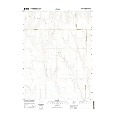
2014 Map of Burger Canyon SE
USGS Topo · Published 2014About this map
The agricultural landscape of Southwest Nebraska is defined by a sophisticated network of irrigation infrastructure designed to manage the flow of water across this high-plains region. Culbertson Canal and the Culbertson Extension Canal trace the elevation contours, serving as critical lifelines for the surrounding farmsteads. These waterways, along with the Blackwood Lateral Canal, intersect the natural drainage of Blackwood Cr, illustrating the intensive modification of the terrain for production. Small-scale water management is evident at the Miller Reservoir, while the presence of the Hock Airport highlights the logistical connectivity required for rural operations. This survey captures a specific moment in the mid-2010s where modern county roads like Road 727 and Road 374 follow section lines, framing the junction of Red Willow, Hitchcock, Hayes, and Frontier counties.
Find a feature on this map
17 named features on this map. Tap any name to fly to it.
Don’t see what you’re looking for? This feature index may not catch every label — zoom into the map to look around manually.
Map Details
Editions of this 2014 Burger Canyon SE Map
This is the sole edition of this map. No revisions or reprints were ever made.
Other maps of this area

1954 · McCook
USGS Topo · 1:250,000

1957 · McCook
USGS Topo · 1:250,000

1958 · McCook
USGS Topo · 1:250,000

1962 · Culbertson NW
USGS Topo · 1:24,000

1970 · Red Willow Dam
USGS Topo · 1:24,000

1970 · Quick
USGS Topo · 1:24,000
1970 · Culbertson
USGS Topo · 1:24,000

1970 · McCook West
USGS Topo · 1:24,000

1970 · Burger Canyon SE
USGS Topo · 1:24,000

1970 · Burger Canyon East
USGS Topo · 1:24,000