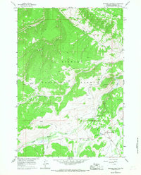
1964 Map of Burgess Junction
USGS Topo · Published 1967About this map
Bighorn National Forest contains a complex network of forest roads and remote seasonal outposts in this 1960s survey. The area is anchored by Burgess Junction, where several routes converge near the Burgess Ranger Station and a local heliport. The landscape is defined by the headwaters of the Tongue River and its various branches, including the North Tongue River and Little Willow Creek. Settlement patterns here reflect the region's ranching and recreational history, evidenced by Wolfe Cow Camp, P K Cow Camp, and the presence of both Bear Lodge and Twin Buttes Lodge.
Find a feature on this map
36 named features on this map. Tap any name to fly to it.
Don’t see what you’re looking for? This feature index may not catch every label — zoom into the map to look around manually.
Map Details
Editions of this 1964 Burgess Junction Map
3 editions found
Other maps of this area

1895 · Dayton
USGS Topo · 1:125,000

1898 · Bald Mountain
USGS Topo · 1:125,000

1901 · Dayton
USGS Topo · 1:125,000

1901 · Bald Mountain
USGS Topo · 1:125,000

1955 · Sheridan
USGS Topo · 1:250,000

1958 · Sheridan
USGS Topo · 1:250,000

1960 · Granite Pass
USGS Topo · 1:24,000

1960 · Hidden Tepee Creek
USGS Topo · 1:24,000

1962 · Sheridan
USGS Topo · 1:250,000
1964 · Skull Ridge
USGS Topo · 1:24,000