
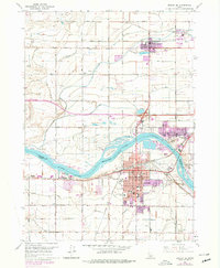
1964 Map of Burley SE
USGS Topo · Published 1966About this map
Snake River geography dominates this mid-1960s study, where the waters of Milner Lake flow past a series of named landforms including Custer Island, Hog Island, and Goat Island. The city of Burley serves as the regional hub, showing a detailed street grid concentrated along Main Street and Overland Ave. The area’s civic infrastructure is well-documented, featuring the Cassia Memorial Hospital, the Armory, and several educational sites like Dworshak Sch and Southwest Sch.
Find a feature on this map
34 named features on this map. Tap any name to fly to it.
Don’t see what you’re looking for? This feature index may not catch every label — zoom into the map to look around manually.
Map Details
Editions of this 1964 Burley SE Map
2 editions found
Other maps of this area

1954 · Pocatello
USGS Topo · 1:250,000

1958 · Pocatello
USGS Topo · 1:250,000

1964 · Burley SW
USGS Topo · 1:24,000

1964 · Burley NE
USGS Topo · 1:24,000

1964 · View
USGS Topo · 1:24,000

1964 · Kenyon
USGS Topo · 1:24,000

1964 · Rupert NW
USGS Topo · 1:24,000

1964 · Burley NW
USGS Topo · 1:24,000

1964 · Burley Butte
USGS Topo · 1:24,000

1964 · Rupert SW
USGS Topo · 1:24,000