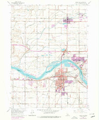
1964 Map of Burley SE
USGS Topo · Published 1979About this map
Burley and its surrounding agricultural valley are defined by a complex network of irrigation and river transport in the mid-1960s. The Milner Lake-Snake River bisects the region, where numerous islands such as Custer Island, Hog Island, and Goat Island create a segmented waterway bridged by the Union Pacific railroad. The layout of the city shows significant institutional growth, featuring several educational facilities like Overland School and Miller School, alongside the Cassia Memorial Hospital and the County Fairgrounds.
Find a feature on this map
38 named features on this map. Tap any name to fly to it.
Don’t see what you’re looking for? This feature index may not catch every label — zoom into the map to look around manually.
Map Details
Editions of this 1964 Burley SE Map
2 editions found

Other maps of this area

1954 · Pocatello
USGS Topo · 1:250,000

1958 · Pocatello
USGS Topo · 1:250,000

1964 · Burley SW
USGS Topo · 1:24,000

1964 · Burley NE
USGS Topo · 1:24,000

1964 · View
USGS Topo · 1:24,000

1964 · Kenyon
USGS Topo · 1:24,000

1964 · Rupert NW
USGS Topo · 1:24,000

1964 · Burley NW
USGS Topo · 1:24,000

1964 · Burley Butte
USGS Topo · 1:24,000

1964 · Rupert SW
USGS Topo · 1:24,000