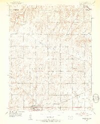
1952 Map of Burlingame
USGS Topo · Published 1953About this map
The Atchison Topeka and Santa Fe railroad corridor serves as the industrial backbone of this Kansas prairie landscape, cutting through the southern half of the township and supporting the town of Burlingame. Extensive evidence of local coal mining is visible northeast of the town site, with numerous Mine Shafts and clusters of Mine Dumps scattered along the rail line, marking a period of intense extraction.
Find a feature on this map
27 named features on this map. Tap any name to fly to it.
Don’t see what you’re looking for? This feature index may not catch every label — zoom into the map to look around manually.
Map Details
Editions of this 1952 Burlingame Map
3 editions found
Other maps of this area

1889 · Burlingame
USGS Topo · 1:125,000

1894 · Burlingame
USGS Topo · 1:125,000

1947 · Lawrence
USGS Topo · 1:250,000

1950 · Lawrence
USGS Topo · 1:250,000

1952 · Auburn
USGS Topo · 1:24,000

1952 · Harveyville
USGS Topo · 1:24,000
1952 · Dover
USGS Topo · 1:24,000

1952 · Burlingame
USGS Topo · 1:24,000
1955 · Wakarusa
USGS Topo · 1:24,000

1955 · Carbondale
USGS Topo · 1:24,000