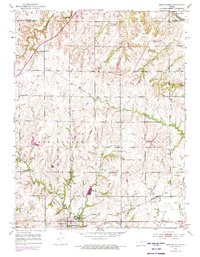
1952 Map of Burlingame
USGS Topo · Published 1973About this map
The town of Burlingame serves as the focal point of this mid-century Osage County landscape, where the Atchison Topeka and Santa Fe railroad corridor defines the local transit and industrial layout. The surrounding territory is marked by a legacy of coal extraction, evidenced by several mine dumps and a mine shaft scattered to the east of the primary settlement. Local social hubs like the Fair Plain Grange Hall and Pleasant Valley Grange Hall reflect the region's agricultural roots, while the rural education system is represented by the Fountain Ridge Sch and Fostoria Sch. The natural drainage of the land is shaped by the Wakarusa R in the north and the winding course of Hundred and Ten Mile Creek, cutting through the undulating plains near Stenger Hill.
Find a feature on this map
21 named features on this map. Tap any name to fly to it.
Don’t see what you’re looking for? This feature index may not catch every label — zoom into the map to look around manually.
Map Details
Editions of this 1952 Burlingame Map
3 editions found
Other maps of this area

1889 · Burlingame
USGS Topo · 1:125,000

1894 · Burlingame
USGS Topo · 1:125,000

1947 · Lawrence
USGS Topo · 1:250,000

1950 · Lawrence
USGS Topo · 1:250,000

1952 · Auburn
USGS Topo · 1:24,000

1952 · Harveyville
USGS Topo · 1:24,000
1952 · Dover
USGS Topo · 1:24,000

1952 · Burlingame
USGS Topo · 1:24,000
1955 · Wakarusa
USGS Topo · 1:24,000

1955 · Carbondale
USGS Topo · 1:24,000