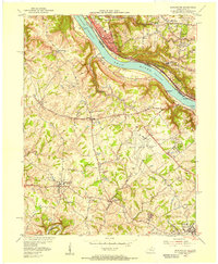
1955 Map of Burlington
USGS Topo · Published 1956About this map
The Ohio River serves as the dominant artery of this 1955 survey, separating Cincinnati and its riverside neighborhoods like Sayler Park and Delhi from the rural landscapes of Boone County. The northern bank is characterized by intensive development and vital transportation links, including the Baltimore and Ohio and New York Central railroads. A key river landmark is Lock and Dam No 37, while the Anderson Ferry provides a rare cross-river connection near Constance.
Find a feature on this map
54 named features on this map. Tap any name to fly to it.
Don’t see what you’re looking for? This feature index may not catch every label — zoom into the map to look around manually.
Map Details
Editions of this 1955 Burlington Map
This is the sole edition of this map. No revisions or reprints were ever made.
Other maps of this area

1914 · West Cincinnati
USGS Topo · 1:62,500

1915 · Lawrenceburg
USGS Topo · 1:48,000

1928 · Lawrenceburg
USGS Topo · 1:62,500

1932 · Lawrenceburg
USGS Topo · 1:62,500

1943 · Rising Sun
USGS Topo · 1:24,000

1943 · Hooven
USGS Topo · 1:24,000

1943 · Lawrenceburg
USGS Topo · 1:24,000

1950 · Union
USGS Topo · 1:24,000

1950 · Independence
USGS Topo · 1:24,000

1950 · Covington
USGS Topo · 1:24,000