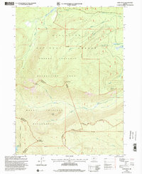
1999 Map of Burn Butte
USGS Topo · Published 2002About this map
Mount Thielsen Wilderness and the Winema National Forest define this high-altitude landscape along the crest of the Cascades. The 1999 revision captures a territory dedicated almost entirely to conservation and recreation, where the Pacific Crest National Scenic Trail winds through the southwestern corner near Miller Mountain. This area serves as a critical headwaters region, with the Little Deschutes River and Big Marsh Creek draining the complex volcanic terrain.
Find a feature on this map
23 named features on this map. Tap any name to fly to it.
Don’t see what you’re looking for? This feature index may not catch every label — zoom into the map to look around manually.
Map Details
Editions of this 1999 Burn Butte Map
This is the sole edition of this map. No revisions or reprints were ever made.
Other maps of this area

1917 · Diamond Lake
USGS Topo · 1:125,000

1935 · Chemult
USGS Topo · 1:96,000

1941 · Chemult
USGS Topo · 1:125,000

1955 · Crescent
USGS Topo · 1:250,000

1956 · Diamond Lake
USGS Topo · 1:62,500

1956 · Summit Lake
USGS Topo · 1:62,500

1957 · Crescent
USGS Topo · 1:250,000

1958 · Crescent
USGS Topo · 1:250,000

1958 · Roseburg
USGS Topo · 1:250,000

1959 · Roseburg
USGS Topo · 1:250,000