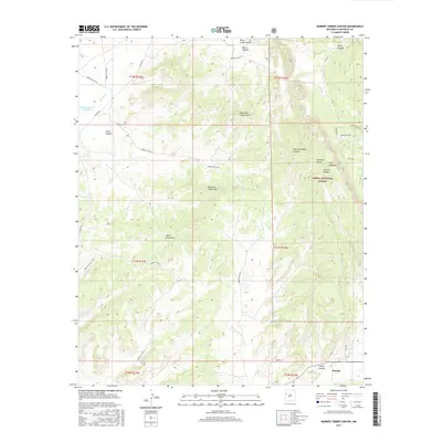
2017 Map of Burned Timber Canyon
USGS Topo · Published 2017About this map
Ramah anchors the southeastern corner of this landscape, situated near where Cebolla Cr winds through Chees Hollow. The terrain is defined by a series of dramatic geographic features including The Hogback and the high points of N Burned Timber Mtn and S Burned Timber Mtn. Much of the eastern portion of the map is preserved as part of the Cibola National Forest, while the western sections are marked by the drainage of Rio Nutria and the waters of Nutria Reservoir Number 3.
Find a feature on this map
36 named features on this map. Tap any name to fly to it.
Don’t see what you’re looking for? This feature index may not catch every label — zoom into the map to look around manually.
Map Details
Editions of this 2017 Burned Timber Canyon Map
This is the sole edition of this map. No revisions or reprints were ever made.
Other maps of this area

1886 · Wingate
USGS Topo · 1:250,000

1892 · Wingate
USGS Topo · 1:250,000

1954 · Gallup
USGS Topo · 1:250,000

1958 · Gallup
USGS Topo · 1:250,000

1959 · Gallup
USGS Topo · 1:250,000

1962 · Gallup
USGS Topo · 1:250,000

1962 · Page
USGS Topo · 1:24,000
1963 · Togeye Lake
USGS Topo · 1:24,000
1963 · Ramah
USGS Topo · 1:24,000

1963 · Pinehaven
USGS Topo · 1:24,000