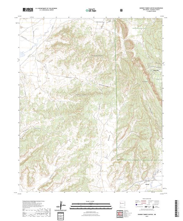
2023 Map of Burned Timber Canyon
USGS Topo · Published 2023About this map
North Burned Timber Mtn and South Burned Timber Mtn define the high terrain of this McKinley County landscape, situated on the edge of the Cibola National Forest. The geography is marked by deep drainage patterns including Burned Timber Canyon, Crow Canyon, and Pescado Draw, which channel seasonal waters toward the Rio Nutria and Cebolla Creek. A distinct geological formation known as The Hogback runs north-to-south near the residential cluster of Timberlake, where a network of local roads like W Bluebird Dr and Conejo Dr serves the area. To the south, the settlement of Ramah occupies the fertile Ramah Valley, positioned at the crossroads of Ansley Rd and Savoia Dr. This survey illustrates the contrast between the protected forest wilderness and the rural ranching or residential developments along Nutria Rd and Indian Svc Rte 26.
Find a feature on this map
38 named features on this map. Tap any name to fly to it.
Don’t see what you’re looking for? This feature index may not catch every label — zoom into the map to look around manually.
Map Details
Editions of this 2023 Burned Timber Canyon Map
This is the sole edition of this map. No revisions or reprints were ever made.
Other maps of this area

1886 · Wingate
USGS Topo · 1:250,000

1892 · Wingate
USGS Topo · 1:250,000

1954 · Gallup
USGS Topo · 1:250,000

1958 · Gallup
USGS Topo · 1:250,000

1959 · Gallup
USGS Topo · 1:250,000

1962 · Gallup
USGS Topo · 1:250,000

1962 · Page
USGS Topo · 1:24,000
1963 · Togeye Lake
USGS Topo · 1:24,000
1963 · Ramah
USGS Topo · 1:24,000

1963 · Pinehaven
USGS Topo · 1:24,000