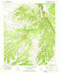
1972 Map of Burned Timber Canyon
USGS Topo · Published 1976About this map
Zuni Indian Reservation and Ramah Indian Reservation lands dominate this mid-century landscape, characterized by complex drainage patterns and dramatic high-altitude features. The prominent ridgeline of The Hogback bisects the eastern portion of the map, while North Burned Timber Mountain and its southern counterpart stand as central landmarks above Burned Timber Canyon. Water management is evident in the northwestern corner at Nutria Res No 3, which feeds into the Rio Nutria.
Find a feature on this map
22 named features on this map. Tap any name to fly to it.
Don’t see what you’re looking for? This feature index may not catch every label — zoom into the map to look around manually.
Map Details
Editions of this 1972 Burned Timber Canyon Map
This is the sole edition of this map. No revisions or reprints were ever made.
Other maps of this area

1886 · Wingate
USGS Topo · 1:250,000

1892 · Wingate
USGS Topo · 1:250,000

1954 · Gallup
USGS Topo · 1:250,000

1958 · Gallup
USGS Topo · 1:250,000

1959 · Gallup
USGS Topo · 1:250,000

1962 · Gallup
USGS Topo · 1:250,000

1962 · Page
USGS Topo · 1:24,000
1963 · Togeye Lake
USGS Topo · 1:24,000
1963 · Ramah
USGS Topo · 1:24,000

1963 · Pinehaven
USGS Topo · 1:24,000