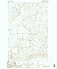
1984 Map of Burnett Creek
USGS Topo · Published 1984About this map
Burnett Creek and its complex network of coulees define this section of Valley County, Montana, as documented in this 1984 provisional study. The landscape is characterized by a series of drainage systems, including Big Coulee and Jensen Coulee, which cut through the high plains. A notable water management feature, the Desert Claim Reservoir, sits along the East Fork Creek, reflecting the importance of water storage in this arid ranching environment. To the south, the terrain drops away into Rock Creek Canyon, where Rock Creek flows. The mapping of named drainages like Badland Coulee and Chisholm Creek provides a precise record of the local hydrology and topographical landmarks used by generations of land managers and residents in the northern Missouri River watershed.
Find a feature on this map
15 named features on this map. Tap any name to fly to it.
Don’t see what you’re looking for? This feature index may not catch every label — zoom into the map to look around manually.
Map Details
Editions of this 1984 Burnett Creek Map
2 editions found
Other maps of this area

1919 · Boundary
USGS Topo · 1:125,000

1954 · Glasgow
USGS Topo · 1:250,000

1957 · Glasgow
USGS Topo · 1:250,000

1958 · Glasgow
USGS Topo · 1:250,000

1984 · Laundry Hill
USGS Topo · 1:24,000

1984 · Snake Creek School
USGS Topo · 1:24,000

1984 · Opheim
USGS Topo · 1:100,000
1984 · Jones Coulee
USGS Topo · 1:24,000

1984 · Gay Dam
USGS Topo · 1:24,000

1984 · Last Chance Reservoir
USGS Topo · 1:24,000