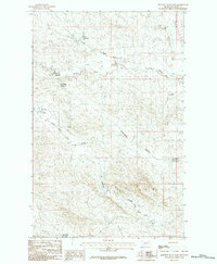
1984 Map of Burnett Flats East
USGS Topo · Published 1984About this map
Burnett Flats and its surrounding ranchlands characterize this 1984 provisional survey of eastern Montana. The landscape is defined by an intricate network of water management features, including Hamms Reservoir, Moccasin Reservoir, and Hurricane Reservoir, which capture runoff from the North Fork and South Fork tributaries. The presence of named drainages like Arrambide Coulee and North Fork Lone Tree Creek reflects the complex hydrology of this part of Valley County.
Find a feature on this map
13 named features on this map. Tap any name to fly to it.
Don’t see what you’re looking for? This feature index may not catch every label — zoom into the map to look around manually.
Map Details
Editions of this 1984 Burnett Flats East Map
This is the sole edition of this map. No revisions or reprints were ever made.
Other maps of this area

1943 · Glasgow
USGS Topo · 1:125,000

1954 · Jordan
USGS Topo · 1:250,000

1954 · Glasgow
USGS Topo · 1:250,000

1956 · Jordan
USGS Topo · 1:250,000

1957 · Glasgow
USGS Topo · 1:250,000

1958 · Glasgow
USGS Topo · 1:250,000

1958 · Jordan
USGS Topo · 1:250,000

1958 · Miller Coulee
USGS Topo · 1:62,500

1958 · Collins Ranch
USGS Topo · 1:62,500
1958 · Billick Coulee
USGS Topo · 1:24,000