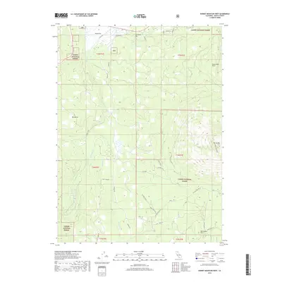
2018 Map of Burney Mountain West
USGS Topo · Published 2018About this map
The volcanic landscape of eastern Shasta County is dominated by the prominent summit of Burney Mtn, where the Burney Mtn Lookout stands watch over the surrounding timberlands. Much of the terrain is contained within the Lassen National Forest, characterized by a series of distinct volcanic features such as Whittington Butte, Ward Butte, and Rocky Ledge Butte. A complex network of forestry and access roads, including Tamarack Rd and Scott Lumber Rd, crisscrosses the slopes, reflecting the region's active management for timber and resource protection. Low-lying areas like Jackrabbit Flat and Haynes Flat provide topographic relief among the peaks. Water sources are sparse in this porous volcanic soil, primarily represented by Indian Spring and the drainage courses of Burney Cr and its tributary, Green Burney Cr, which flow northward through the forest toward the Pit River basin.
Find a feature on this map
32 named features on this map. Tap any name to fly to it.
Don’t see what you’re looking for? This feature index may not catch every label — zoom into the map to look around manually.
Map Details
Editions of this 2018 Burney Mountain West Map
This is the sole edition of this map. No revisions or reprints were ever made.
Other maps of this area

1886 · Lassen Peak
USGS Topo · 1:250,000

1892 · Lassen Peak
USGS Topo · 1:250,000

1894 · Lassen Peak
USGS Topo · 1:250,000

1935 · Burney
USGS Topo · 1:96,000

1939 · Burney
USGS Topo · 1:125,000

1955 · Westwood
USGS Topo · 1:250,000

1956 · Manzanita Lake
USGS Topo · 1:62,500
1956 · Whitmore
USGS Topo · 1:62,500
1956 · Montgomery Creek
USGS Topo · 1:62,500

1957 · Burney
USGS Topo · 1:62,500