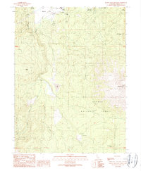
1990 Map of Burney Mountain West
USGS Topo · Published 1990About this map
Burney sits at the northern edge of this topographical study, marking a transition between the northern valley flats and the volcanic peaks of the southern landscape. The terrain is dominated by the volcanic forms of the southern Cascades, rising toward the summit of Burney Mountain and the high points of Whittington Butte and Ward Butte. Much of the area falls within the Lassen National Forest, showing a network of mountain drainage patterns including Burney Creek and Haynes Flat Creek. A notable site for local history is the Old Green Burney Camp, located west of the seasonal Dry Lake. The map details the transition from the relatively level Jackrabbit Flat and Haynes Flat Creek into the heavily contoured timberlands where Indian Spring and various forest roads serve the high country.
Find a feature on this map
18 named features on this map. Tap any name to fly to it.
Don’t see what you’re looking for? This feature index may not catch every label — zoom into the map to look around manually.
Map Details
Editions of this 1990 Burney Mountain West Map
This is the sole edition of this map. No revisions or reprints were ever made.
Other maps of this area

1886 · Lassen Peak
USGS Topo · 1:250,000

1892 · Lassen Peak
USGS Topo · 1:250,000

1894 · Lassen Peak
USGS Topo · 1:250,000

1935 · Burney
USGS Topo · 1:96,000

1939 · Burney
USGS Topo · 1:125,000

1955 · Westwood
USGS Topo · 1:250,000

1956 · Manzanita Lake
USGS Topo · 1:62,500
1956 · Whitmore
USGS Topo · 1:62,500
1956 · Montgomery Creek
USGS Topo · 1:62,500

1957 · Burney
USGS Topo · 1:62,500