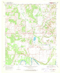
1968 Map of Burneyville
USGS Topo · Published 1971About this map
Hickory Bayou and Walnut Bayou dominate the drainage patterns of this Love County landscape as it appeared in the late 1960s. The terrain is defined by the sharp, wandering loops of the Red River at the southern boundary, where significant geographic features like Warrens Bend and Tyas Bend mark the Indefinite Boundary between Oklahoma and Texas. This survey captures a rural network of small communities including Burneyville, Turner, and Eastman, with local infrastructure such as the Landing Field Burneyville and several dispersed Oil Wells illustrating the mid-century economy of the region.
Find a feature on this map
28 named features on this map. Tap any name to fly to it.
Don’t see what you’re looking for? This feature index may not catch every label — zoom into the map to look around manually.
Map Details
Editions of this 1968 Burneyville Map
2 editions found
Other maps of this area

1901 · Ardmore
USGS Topo · 1:125,000

1902 · Gainesville
USGS Topo · 1:125,000

1918 · Ardmore
USGS Topo · 1:125,000

1943 · Gainesville
USGS Topo · 1:125,000

1954 · Sherman
USGS Topo · 1:250,000

1957 · Ardmore
USGS Topo · 1:250,000

1958 · Sherman
USGS Topo · 1:250,000

1963 · Ardmore
USGS Topo · 1:250,000

1964 · Overbrook
USGS Topo · 1:24,000
1968 · Thackerville
USGS Topo · 1:24,000