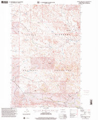
1997 Map of Burning Mine Butte
USGS Topo · Published 2001About this map
Burning Mine Butte stands as a prominent landmark within the expansive Little Missouri National Grassland, characterizing a landscape defined by sharp elevation changes and a dense network of seasonal drainages. In the late 1990s, the region maintained its identity as a site of active ranching and natural resource extraction. Evidence of the local livestock economy is seen in family-held holdings like A Moe Ranch and D Crighton Ranch, while an active Oil Field north of Bowline Creek points to the industrial footprint in this part of McKenzie County.
Find a feature on this map
23 named features on this map. Tap any name to fly to it.
Don’t see what you’re looking for? This feature index may not catch every label — zoom into the map to look around manually.
Map Details
Editions of this 1997 Burning Mine Butte Map
This is the sole edition of this map. No revisions or reprints were ever made.
Other maps of this area

1953 · Watford City
USGS Topo · 1:250,000

1957 · Watford City
USGS Topo · 1:250,000

1967 · Watford City
USGS Topo · 1:250,000

1972 · Bear Butte
USGS Topo · 1:24,000

1972 · Moline School
USGS Topo · 1:24,000

1972 · Sheep Creek
USGS Topo · 1:24,000

1972 · Sather Lake
USGS Topo · 1:24,000
1972 · Burning Mine Butte
USGS Topo · 1:24,000
1974 · Ice Box Canyon
USGS Topo · 1:24,000
1974 · Cinnamon Creek
USGS Topo · 1:24,000