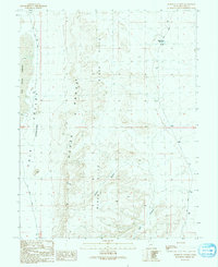
1991 Map of Burnout Canyon
USGS Topo · Published 1991About this map
The House Range and the Black Hills dominate this arid landscape in western Millard County, revealing a terrain of dramatic vertical relief and geologic complexity. This 1991 provisional edition captures the basin-and-range character of the region, where the broad Tule Valley (Depression) is flanked by these rising formations. The presence of Hardpan and the Sevier Lake Reservoir suggests a seasonal and highly variable water system typical of the Great Basin. Transportation through this remote stretch of Utah is limited to unpaved routes, including the Tule Valley Road and the CCC Road, the latter nodding to the work projects of the Civilian Conservation Corps era. Names like Burnout Canyon and Red Canyon provide specific landmarks for those navigating the eastern slopes of the range, offering a look at the drainage patterns before they descend into the valley floor.
Find a feature on this map
11 named features on this map. Tap any name to fly to it.
Don’t see what you’re looking for? This feature index may not catch every label — zoom into the map to look around manually.
Map Details
Editions of this 1991 Burnout Canyon Map
This is the sole edition of this map. No revisions or reprints were ever made.
Other maps of this area

1908 · Fish Springs
USGS Topo · 1:250,000

1910 · Fish Springs
USGS Topo · 1:250,000

1953 · Richfield
USGS Topo · 1:250,000

1953 · Delta
USGS Topo · 1:250,000

1958 · Richfield
USGS Topo · 1:250,000

1958 · Delta
USGS Topo · 1:250,000

1960 · Notch Peak
USGS Topo · 1:62,500

1960 · The Barn
USGS Topo · 1:62,500

1962 · Delta
USGS Topo · 1:250,000
1972 · Needle Point
USGS Topo · 1:24,000