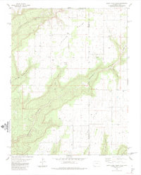
1985 Map of Burnt Cabin Creek
USGS Topo · Published 1985About this map
The high plateau of Cedar Point and Bug Point dominates this 1980s landscape on the Utah Colorado border, where deep drainages like Monument Canyon and Coal Bed Canyon carve through the terrain. The map records a sparse settlement pattern tied to ranching and local infrastructure, evidenced by scattered storage bins, a Corral, and the Cedar Cem. Water sources were critical in this arid environment, with several named points of interest such as Burnt Cabin Spring, Oak Spring, and Bug Spring providing vital resources away from the larger seasonal flows of Burnt Cabin Creek. The survey also documents localized industrial activity, including a Gravel Pit and a remote Drill Hole, reflecting the mid-20th-century exploration of the region's natural resources.
Find a feature on this map
25 named features on this map. Tap any name to fly to it.
Don’t see what you’re looking for? This feature index may not catch every label — zoom into the map to look around manually.
Map Details
Editions of this 1985 Burnt Cabin Creek Map
This is the sole edition of this map. No revisions or reprints were ever made.
Other maps of this area

1886 · Abajo
USGS Topo · 1:250,000

1892 · Abajo
USGS Topo · 1:250,000

1893 · Abajo
USGS Topo · 1:250,000

1955 · Verdure 4 NW
USGS Topo · 1:24,000

1955 · Verdure 1 SW
USGS Topo · 1:24,000

1955 · Verdure 4 SW
USGS Topo · 1:24,000

1956 · Cortez
USGS Topo · 1:250,000

1957 · Cedar 3 NW
USGS Topo · 1:24,000

1957 · Cedar 3 SW
USGS Topo · 1:24,000

1957 · Monument Canyon
USGS Topo · 1:62,500