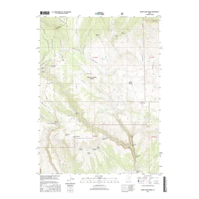
2017 Map of Burnt Cabin Gorge
USGS Topo · Published 2017About this map
Ashley National Forest dominates this landscape in northeastern Utah, where the southern slopes of the Uinta Mountains transition into the high Diamond Mountain Plateau. The area is defined by a dense network of canyons and draws, including the eponymous Burnt Cabin Gorge and the notable Hole in the Wall Canyon. Human presence is marked by infrastructure supporting backcountry recreation and resource management, such as the Old Ski Tow near the Daggett County line and the Limber Flag Yurt Trail. Water management is evident through scattered features like the Counting Station Reservoir and Association Reservoir, which serve this arid high-elevation terrain. Historical land use is further reflected in traditional routes like the Ashley Driveway and family-named landmarks such as Mary Cashen Canyon.
Find a feature on this map
66 named features on this map. Tap any name to fly to it.
Don’t see what you’re looking for? This feature index may not catch every label — zoom into the map to look around manually.
Map Details
Editions of this 2017 Burnt Cabin Gorge Map
This is the sole edition of this map. No revisions or reprints were ever made.
Other maps of this area

1885 · Ashley
USGS Topo · 1:250,000

1906 · Marsh Peak
USGS Topo · 1:125,000

1908 · Marsh Peak
USGS Topo · 1:125,000

1950 · Burnt Cabin Gorge
USGS Topo · 1:24,000

1950 · Blair Basin
USGS Topo · 1:24,000

1950 · Dyer Mountain
USGS Topo · 1:24,000

1954 · Vernal
USGS Topo · 1:250,000

1958 · Vernal
USGS Topo · 1:250,000

1960 · Vernal
USGS Topo · 1:250,000
1963 · East Park Reservoir
USGS Topo · 1:24,000