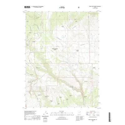
2020 Map of Burnt Cabin Gorge
USGS Topo · Published 2020About this map
The southern slopes of the Uinta Mountains dominate this 2020 landscape, where the high-altitude terrain of the Ashley National Forest transitions into complex canyon systems. The map detail highlights an intricate network of seasonal water sources and drainages, including Reader Cr, Bassett Cr, and the deep incision of Burnt Cabin Gorge. Evidence of land management and recreational infrastructure is present through the naming of the Bassett Springs X-C Ski Loop and several mountain reservoirs such as Counting Station Reservoir. Significant topographical features like Little Brush Creek Knob and the Diamond Mountain Plateau define the local relief. Genealogists and local historians can trace family-named landmarks including Dutch Charles Draw and Mary Cashen Canyon, which offer clues to the early ranching and homesteading history of the region.
Find a feature on this map
60 named features on this map. Tap any name to fly to it.
Don’t see what you’re looking for? This feature index may not catch every label — zoom into the map to look around manually.
Map Details
Editions of this 2020 Burnt Cabin Gorge Map
This is the sole edition of this map. No revisions or reprints were ever made.
Other maps of this area

1885 · Ashley
USGS Topo · 1:250,000

1906 · Marsh Peak
USGS Topo · 1:125,000

1908 · Marsh Peak
USGS Topo · 1:125,000

1950 · Burnt Cabin Gorge
USGS Topo · 1:24,000

1950 · Blair Basin
USGS Topo · 1:24,000

1950 · Dyer Mountain
USGS Topo · 1:24,000

1954 · Vernal
USGS Topo · 1:250,000

1958 · Vernal
USGS Topo · 1:250,000

1960 · Vernal
USGS Topo · 1:250,000
1963 · East Park Reservoir
USGS Topo · 1:24,000