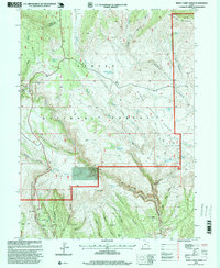
1996 Map of Burnt Cabin Gorge
USGS Topo · Published 1999About this map
Ashley National Forest dominates this high-altitude landscape, where the Diamond Mountain Plateau drops off into the deep drainage of Burnt Cabin Gorge. The map reveals a land defined by water management and topography, featuring remote water sources like Diamond Mountain Spring, Barker Spring, and the Association Reservoir. To the south, the terrain becomes increasingly complex as the plateau breaks into a network of steep-walled ravines, including Independence Canyon and Jackpot Canyon. This 1990s record of the Daggett and Uintah county line captures the specialized infrastructure of the region, from the Counting Station to the legendary pass of Hole-in-The-Wall. The distribution of scattered mines and gravel pits among landmarks like Limestone Mountain reflects the area's mixed use for natural resource extraction and forest management within the canyon systems of the Green River watershed.
Find a feature on this map
51 named features on this map. Tap any name to fly to it.
Don’t see what you’re looking for? This feature index may not catch every label — zoom into the map to look around manually.
Map Details
Editions of this 1996 Burnt Cabin Gorge Map
This is the sole edition of this map. No revisions or reprints were ever made.
Other maps of this area

1885 · Ashley
USGS Topo · 1:250,000

1906 · Marsh Peak
USGS Topo · 1:125,000

1908 · Marsh Peak
USGS Topo · 1:125,000

1950 · Burnt Cabin Gorge
USGS Topo · 1:24,000

1950 · Blair Basin
USGS Topo · 1:24,000

1950 · Dyer Mountain
USGS Topo · 1:24,000

1954 · Vernal
USGS Topo · 1:250,000

1958 · Vernal
USGS Topo · 1:250,000

1960 · Vernal
USGS Topo · 1:250,000
1963 · East Park Reservoir
USGS Topo · 1:24,000