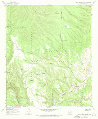
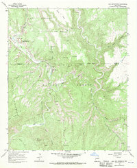
1967 Map of Burnt Corral Canyon
USGS Topo · Published 1971About this map
Gila National Forest encompasses this landscape of deep drainages and high mesas as it appeared in the late 1960s. The area is defined by its complex network of seasonal water sources and livestock infrastructure, including numerous tanks and wells such as Windfall Mesa Well and Preacher Tank. Evidence of early 20th-century conservation and development work appears in labels like CCC Canyon and CCC Tank, while the presence of Trail End Ranch near the Gila River indicates the ongoing ranching heritage of the region. The map captures a transition in land use, showing an Indefinite Wilderness Boundary winding across high points like Jordan Mesa and North Mesa. From the distinct geological formation at Whiterocks to the various springs like House Spring and Adobe Spring, the map documents the vital water locations that supported backcountry navigation and local agriculture.
Find a feature on this map
73 named features on this map. Tap any name to fly to it.
Don’t see what you’re looking for? This feature index may not catch every label — zoom into the map to look around manually.
Map Details
Editions of this 1967 Burnt Corral Canyon Map
This is the sole edition of this map. No revisions or reprints were ever made.
Other maps of this area

1911 · Alum Mountain
USGS Topo · 1:125,000

1913 · Alum Mountain
USGS Topo · 1:125,000

1954 · Clifton
USGS Topo · 1:250,000

1957 · Clifton
USGS Topo · 1:250,000

1958 · Clifton
USGS Topo · 1:250,000

1962 · Clifton
USGS Topo · 1:250,000
1965 · Canyon Creek Mountains
USGS Topo · 1:24,000
1965 · Middle Mesa
USGS Topo · 1:24,000
1965 · Woodland Park
USGS Topo · 1:24,000
1965 · Gila Hot Springs
USGS Topo · 1:24,000