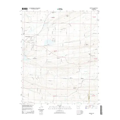
2014 Map of Burnville
USGS Topo · Published 2014About this map
Greenwood and the neighboring hills of Sebastian and Logan Counties are defined by the prominent east-west ridges of the Ouachita foothills. Devils Backbone Ridge and Pinnacle Ridge provide a topographical spine through the center of the sheet, separating the drainages of Vache Grasse Creek to the north and Washburn Creek to the south. This 2014 survey documents the modern layout of rural settlements like Burnville, Milltown, and Carnis, where residential growth extends along the historic corridors of Ar-10 and Ar-96. For those researching local history, the map identifies several significant burial grounds, including Mc Connel, Greenwood Cem, and Dawson Memorial Cem, which are often the last standing indicators of early family homesteads in this part of Arkansas. The terrain is deeply carved by numerous branches like Vineyard Br and Henry Br, illustrating the hydrological network that shaped early land use in the Washburn Mountains area.
Find a feature on this map
99 named features on this map. Tap any name to fly to it.
Don’t see what you’re looking for? This feature index may not catch every label — zoom into the map to look around manually.
Map Details
Editions of this 2014 Burnville Map
This is the sole edition of this map. No revisions or reprints were ever made.
Other maps of this area

1879 · Fort Smith
USGS Topo · 1:62,500

1887 · Van Buren
USGS Topo · 1:62,500

1887 · Greenwood
USGS Topo · 1:62,500

1890 · Fort Smith
USGS Topo · 1:125,000

1906 · Lavaca
USGS Topo · 1:62,500

1906 · Barber
USGS Topo · 1:62,500

1943 · Fort Smith
USGS Topo · 1:125,000

1946 · Fort Smith
USGS Topo · 1:250,000
1946 · Charleston
USGS Topo · 1:24,000

1947 · Lavaca
USGS Topo · 1:62,500