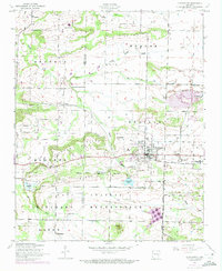
1946 Map of Charleston
USGS Topo · Published 1973About this map
Charleston serves as the focal point of this mid-century survey, situated along the Missouri Pacific line at the border of Sebastian and Franklin Counties. The landscape is a mix of agricultural prairie and growing industrial extraction, evidenced by the presence of a strip mine and an abandoned strip mine to the east and south of the town center. To the south, the expansive Fort Chaffee Military Reservation dominates the terrain, featuring landmarks like Potato Hill and specialized structures such as a Concrete dugout.
Find a feature on this map
33 named features on this map. Tap any name to fly to it.
Don’t see what you’re looking for? This feature index may not catch every label — zoom into the map to look around manually.
Map Details
Editions of this 1946 Charleston Map
2 editions found
Other maps of this area

1887 · Magazine Mountain #2
USGS Topo · 1:62,500

1887 · Magazine Mountain #3
USGS Topo · 1:62,500

1887 · Magazine Mountain
USGS Topo · 1:62,500

1890 · Magazine Mountain
USGS Topo · 1:125,000

1890 · Fort Smith
USGS Topo · 1:125,000

1906 · Lavaca
USGS Topo · 1:62,500

1906 · Barber
USGS Topo · 1:62,500

1934 · Booneville
USGS Topo · 1:48,000

1939 · Booneville
USGS Topo · 1:62,500

1943 · Fort Smith
USGS Topo · 1:125,000