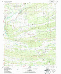
1987 Map of Burnville
USGS Topo · Published 1988About this map
Fort Chaffee Military Reservation dominates the northern landscape of this Sebastian County region, where the terrain is defined by a series of prominent east-west ridges including Devils Backbone Ridge, Pinnacle Ridge, and the White Oak Mountains. Between these elevations, the 1980s landscape reveals a rural economy transitioning toward resource extraction, evidenced by the numerous Gas Wells scattered throughout the Washburn Mountains. The small settlements of Burnville, Milltown, and Chismville serve as local hubs, connected by winding routes like Burnville Road. Genealogists will find several burial sites preserved across the valley, such as Liberty Cem near the Greenwood Corporate Boundary and the secluded Stone Cem near Big Creek Narrows. The drainage of Vache Grasse Creek and Washburn Creek ties together the agricultural and industrial character of the area just before the turn of the 21st century.
Find a feature on this map
47 named features on this map. Tap any name to fly to it.
Don’t see what you’re looking for? This feature index may not catch every label — zoom into the map to look around manually.
Map Details
Editions of this 1987 Burnville Map
This is the sole edition of this map. No revisions or reprints were ever made.
Other maps of this area

1879 · Fort Smith
USGS Topo · 1:62,500

1887 · Van Buren
USGS Topo · 1:62,500

1887 · Greenwood
USGS Topo · 1:62,500

1890 · Fort Smith
USGS Topo · 1:125,000

1906 · Lavaca
USGS Topo · 1:62,500

1906 · Barber
USGS Topo · 1:62,500

1943 · Fort Smith
USGS Topo · 1:125,000

1946 · Fort Smith
USGS Topo · 1:250,000
1946 · Charleston
USGS Topo · 1:24,000

1947 · Lavaca
USGS Topo · 1:62,500