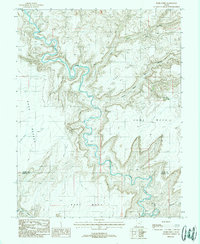
1988 Map of Burr Point
USGS Topo · Published 1988About this map
The Dirty Devil River carves a deep, serpentine path through this high desert plateau, creating a dramatic landscape of isolated mesas and sharp drop-offs. The mapping of this area, based on 1981 aerial photography, illustrates the stark divide between Sams Mesa and Bert Mesa. Human presence is minimal and highly specialized, evidenced by a remote Landing Strip positioned above the river's winding canyon walls. The boundary between Wayne Co and Garfield Co cuts across the southern portion of the sheet, dividing a terrain defined more by its geology than by political borders. Researchers can find natural water sources like Sams Mesa Spring and the wide drainage of Adobe Swale, which provide rare landmarks in an otherwise unforgiving environment of caprock and sandstone.
Find a feature on this map
8 named features on this map. Tap any name to fly to it.
Don’t see what you’re looking for? This feature index may not catch every label — zoom into the map to look around manually.
Map Details
Editions of this 1988 Burr Point Map
2 editions found
Other maps of this area

1885 · San Rafael
USGS Topo · 1:250,000

1952 · Orange Cliffs 3 SW
USGS Topo · 1:24,000

1952 · Bull Mountain
USGS Topo · 1:62,500

1953 · Orange Cliffs 3 SE
USGS Topo · 1:24,000

1953 · Orange Cliffs 3 NE
USGS Topo · 1:24,000

1953 · Orange Cliffs 3 NW
USGS Topo · 1:24,000

1953 · Fiddler Butte
USGS Topo · 1:62,500

1956 · Salina
USGS Topo · 1:250,000

1960 · Salina
USGS Topo · 1:250,000

1962 · Salina
USGS Topo · 1:250,000