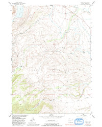
1952 Map of Burris
USGS Topo · Published 1991About this map
Wind River Indian Reservation lands dominate this mid-century topographic record, showcasing a complex water management system designed for high-altitude ranching and agriculture. The small settlement of Burris sits near the upper right, while the Hidden Valley Ranch is located within the dramatic relief of Hidden Valley. The landscape is defined by the significant elevation changes of Dinwoody Ridge and a network of human-engineered waterways, including the Wind River Canal, the Dry Creek Canal, and numerous unnamed ditches. These features illustrate how water from sources like Dinwoody Lake and Upper Dinwoody Lake was redirected across the terrain. A Guard Station and several remote springs provide points of interest for those researching the early administrative and logistical history of the reservation and its surrounding wilderness borders.
Find a feature on this map
20 named features on this map. Tap any name to fly to it.
Don’t see what you’re looking for? This feature index may not catch every label — zoom into the map to look around manually.
Map Details
Editions of this 1952 Burris Map
4 editions found
Other maps of this area

1952 · Wilderness
USGS Topo · 1:24,000

1952 · Hays Park
USGS Topo · 1:24,000

1952 · Crowheart NW
USGS Topo · 1:24,000

1952 · Bob Lakes
USGS Topo · 1:24,000

1952 · Bull Lake West
USGS Topo · 1:24,000

1952 · Blue Holes
USGS Topo · 1:24,000

1952 · Crowheart
USGS Topo · 1:24,000

1952 · Burris
USGS Topo · 1:24,000

1952 · Kirkland Park
USGS Topo · 1:24,000

1955 · Thermopolis
USGS Topo · 1:250,000