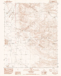
1982 Map of Burro Canyon
USGS Topo · Published 1983About this map
The Argus Range and Indian Wells Valley define this Cold War-era landscape, dominated by the expansive operations of the China Lake Naval Weapons Center. The map reveals a transition from traditional desert resource extraction to sophisticated military testing during the late 1970s and early 1980s. Evidence of earlier human activity is preserved at the Paxton Ranch (Site) and scattered mining operations such as the Star of the West Mine and Sterling Queen Mine. These are juxtaposed against modern installations including the Burro Canyon Test Facility, an Observation Tower, and a Tracking Station. The terrain is characterized by complex drainage systems like Wilson Canyon and Sweetwater Wash, leading toward the southern terminus at China Lake. Notable landmarks like Lone Butte and several phototheodolite stations highlight the specialized surveying and tracking activities central to this high-desert facility.
Find a feature on this map
20 named features on this map. Tap any name to fly to it.
Don’t see what you’re looking for? This feature index may not catch every label — zoom into the map to look around manually.
Map Details
Editions of this 1982 Burro Canyon Map
This is the sole edition of this map. No revisions or reprints were ever made.
Other maps of this area

1915 · Searles Lake
USGS Topo · 1:250,000

1947 · Trona
USGS Topo · 1:250,000

1948 · Trona
USGS Topo · 1:250,000

1949 · Trona
USGS Topo · 1:62,500

1949 · Searles Lake
USGS Topo · 1:62,500

1950 · Searles Lake
USGS Topo · 1:62,500

1950 · Trona
USGS Topo · 1:62,500

1953 · Mountain Springs Canyon
USGS Topo · 1:62,500

1953 · Ridgecrest
USGS Topo · 1:62,500

1953 · Trona
USGS Topo · 1:250,000