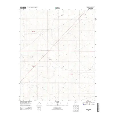
2013 Map of Burro Lake
USGS Topo · Published 2013About this map
Burro Lake serves as a primary geographical anchor in this arid region of Guadalupe County, where water resources and ranching infrastructure define the landscape. The map reveals a sparse network of essential water-drawing sites necessary for land management, including the North Winkle Windmill, Winkle Windmill, and Block Windmill. These features, along with San Pablo Windmill, reflect the reliance on groundwater in an environment shaped by ephemeral drainages like San Pablo Draw. The diagonal transit of Us-54 N provides the only major thoroughfare through these expansive range lands, connecting the distant horizons of the high plains. This 2013 survey documents the intersection of modern transportation and traditional high-desert land use patterns, preserving the locations of specific family-named landmarks that have supported local commerce for generations.
Find a feature on this map
11 named features on this map. Tap any name to fly to it.
Don’t see what you’re looking for? This feature index may not catch every label — zoom into the map to look around manually.
Map Details
Editions of this 2013 Burro Lake Map
This is the sole edition of this map. No revisions or reprints were ever made.
Other maps of this area

1954 · Fort Sumner
USGS Topo · 1:250,000

1958 · Fort Sumner
USGS Topo · 1:250,000
1978 · George Ranch
USGS Topo · 1:24,000

1978 · Mesa Leon
USGS Topo · 1:24,000
1978 · Tapia Ranch
USGS Topo · 1:24,000

1978 · Vaughn
USGS Topo · 1:24,000

1978 · El Morro Ranch
USGS Topo · 1:24,000
1978 · Pastura
USGS Topo · 1:24,000

1978 · El Morro Ranch NW
USGS Topo · 1:24,000

1978 · Long Draw
USGS Topo · 1:24,000