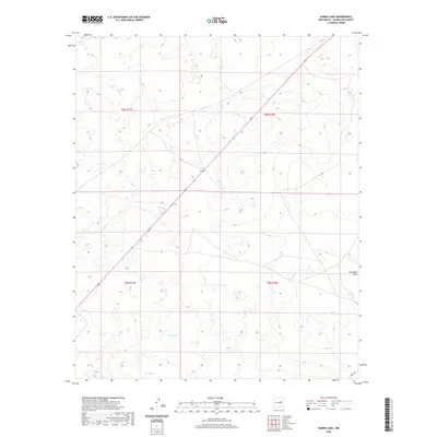
2020 Map of Burro Lake
USGS Topo · Published 2020About this map
Burro Lake serves as the central geographic point of this high-plains landscape in Guadalupe County. This arid terrain is defined by its drainage patterns and the Public Land Survey System, which divides the region into t6n r17e, t6n r18e, t5n r17e, and t5n r18e. Modern infrastructure is minimal, represented primarily by Perez Rd in the southeastern corner. The intermittent water flow of San Pablo Draw marks the eastern edge of the quadrangle, illustrating the subtle topographical variations and natural catchments that dictated land use and ranching boundaries in this part of New Mexico during the early twenty-first century.
Find a feature on this map
7 named features on this map. Tap any name to fly to it.
Don’t see what you’re looking for? This feature index may not catch every label — zoom into the map to look around manually.
Map Details
Editions of this 2020 Burro Lake Map
This is the sole edition of this map. No revisions or reprints were ever made.
Other maps of this area

1954 · Fort Sumner
USGS Topo · 1:250,000

1958 · Fort Sumner
USGS Topo · 1:250,000
1978 · George Ranch
USGS Topo · 1:24,000

1978 · Mesa Leon
USGS Topo · 1:24,000
1978 · Tapia Ranch
USGS Topo · 1:24,000

1978 · Vaughn
USGS Topo · 1:24,000

1978 · El Morro Ranch
USGS Topo · 1:24,000
1978 · Pastura
USGS Topo · 1:24,000

1978 · El Morro Ranch NW
USGS Topo · 1:24,000

1978 · Long Draw
USGS Topo · 1:24,000