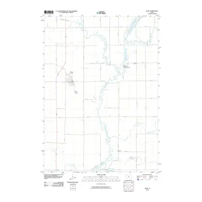
2010 Map of Burt
USGS Topo · Published 2010About this map
The town of Burt serves as the focal point of this rural northern Iowa landscape, where a geometric grid of section roads meets the winding course of the East Fork Des Moines River. In the mid-2000s, the community layout remains centered around the Burt Post Office, while the surrounding countryside is defined by agricultural drainage systems like Drainage Ditch No 69 and several water management features, including the Buffalo Creek Game Management Dam. Genealogy researchers will find several well-established burial grounds documented here, such as the Burt Township Cemetery, Portland Cemetery, and Plum Creek Cemetery. The river corridor is notable for its numerous oxbows and pools, such as Smith Pool and Lowe Pool, reflecting a hydrologic pattern of low-relief prairie streams that often fluctuate between marshes and open water, further managed by the Oak Lake Dam near the southern boundary.
Find a feature on this map
36 named features on this map. Tap any name to fly to it.
Don’t see what you’re looking for? This feature index may not catch every label — zoom into the map to look around manually.
Map Details
Editions of this 2010 Burt Map
This is the sole edition of this map. No revisions or reprints were ever made.
Other maps of this area

1954 · Fairmont
USGS Topo · 1:250,000

1958 · Fairmont
USGS Topo · 1:250,000

1972 · German Valley
USGS Topo · 1:24,000

1972 · Algona
USGS Topo · 1:24,000

1972 · Bancroft
USGS Topo · 1:24,000

1972 · Titonka
USGS Topo · 1:24,000

1972 · Burt
USGS Topo · 1:24,000
1972 · Sexton
USGS Topo · 1:24,000

1980 · Lone Rock
USGS Topo · 1:24,000

1980 · Armstrong SE
USGS Topo · 1:24,000