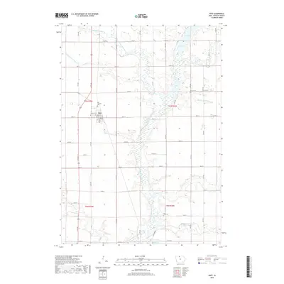
2018 Map of Burt
USGS Topo · Published 2018About this map
The town of Burt serves as the focal point for this section of Kossuth County, situated in a landscape defined by highly managed water systems and traditional agricultural divisions. The East Fork Des Moines River winds through the central terrain, flanked by a series of engineered watercourses including Drainage Ditch Number 69, Drainage Ditch Number 63, and Drainage Ditch Number 175. This complex hydrology reflects the region's intensive land use and the transformation of the prairie into a productive farming grid. Local history and genealogy are anchored by several established burial grounds such as Burt Township Cem, Portland Cem, and Plum Creek Cem. Tributaries like Lindsey Creek and Black Cat Cr feed into the river system, alongside notable local features like Oak Lake, Smith Pool, and Lowe Pool.
Find a feature on this map
53 named features on this map. Tap any name to fly to it.
Don’t see what you’re looking for? This feature index may not catch every label — zoom into the map to look around manually.
Map Details
Editions of this 2018 Burt Map
This is the sole edition of this map. No revisions or reprints were ever made.
Other maps of this area

1954 · Fairmont
USGS Topo · 1:250,000

1958 · Fairmont
USGS Topo · 1:250,000

1972 · German Valley
USGS Topo · 1:24,000

1972 · Algona
USGS Topo · 1:24,000

1972 · Bancroft
USGS Topo · 1:24,000

1972 · Titonka
USGS Topo · 1:24,000

1972 · Burt
USGS Topo · 1:24,000
1972 · Sexton
USGS Topo · 1:24,000

1980 · Lone Rock
USGS Topo · 1:24,000

1980 · Armstrong SE
USGS Topo · 1:24,000